Clean Waters Partnership: When the water rises, are we prepared?
Thursday, April 14, 2022
By Caitlin Yoder, Watershed Coordinator
The Clean Waters Partnership interviewed Ed Rock, Emergency Management Director for Kosciusko County, to learn about flooding in our area and what resources are available to deal with their impact.
How does flooding effect our watershed?
The Upper Tippecanoe Watershed is hallmarked by the abundance of water, including hundreds of lakes, streams, and wetlands.
With the draw of the lakes and the nutrient rich soil, we have built thriving communities, industry, and productive farms. However, the natural topography of the land combined with development designed to fast-track water off surfaces leads to flooding during a large rain event.
What kinds of flooding do we see?
Most river flooding occurs in early spring and is the result of excessive rainfall and/or the combination of rainfall and snowmelt. Severe thunderstorms may cause flooding during the summer or fall but tend to be localized. According to the Kosciusko County Hazard Analysis, the primary source of river flooding is the Tippecanoe River. Although the Eel River in the southwest corner of the county is prone to flooding, it impacts only a small portion of land that is primarily farmland, wetlands, and wildland.
Flash floods, and brief heavy flows in small streams or normally dry creek beds, also occur within the county. Flash flooding is typically characterized by high-velocity water, often carrying large amounts of debris.
Urban flooding involves the overflow of storm drain systems and is also typically the result of inadequate drainage following heavy rainfall or rapid snowmelt.
Who monitors flooding and floodplains?
County and local governments use the National Weather Service and the Advanced Hydrologic Prediction Service to monitor precipitation and any resulting flooding.
The Lilly Center for Lakes & Streams also monitors rain events and has live data available for 11 inflows and outlets on Wawasee, Tippecanoe and Winona Lake.
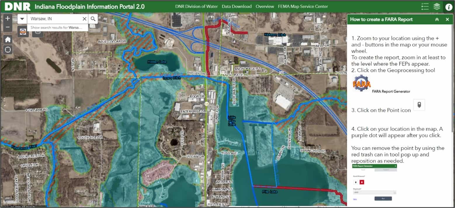
The Department of Natural Resources website contains a wealth of information on floodplains and flooding in Indiana. These floodplain boundaries are decided through a collaboration between FEMA and the National Flood Insurance Program with cooperation from the individual counties. This link contains new DNR Floodplain Information Portal that shows the most recent 100-year floodplain. All you have to do is type in your address to see where your property sits.
Intelligent and well-thought-out development in floodplains is the key to reducing flood-related damages by avoiding interactions with water in the first place.
Does Kosciusko County have a plan for dealing with flooding?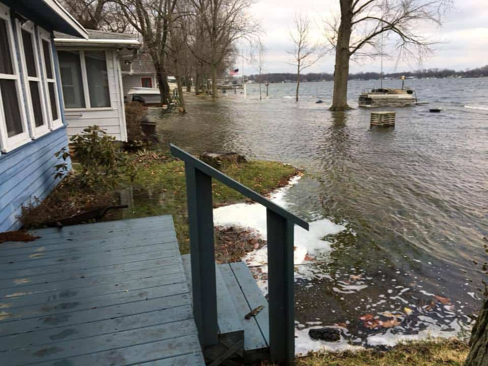
Yes! It is part of the larger Multi-hazard Mitigation Plan to identify natural hazards, corresponding actions and activities to reduce losses, and develop a coordinated process to deal with the threats. Other hazards in this plan include tornado, earthquake, thunderstorm, drought, winter storm, hazardous material, fire, and infectious disease within Kosciusko County.
Summary of Multi-Hazard Mitigation Flood Plan:
- The county is committed to infrastructure projects and maintenance on storm drains, culverts, bridges, etc. to help alleviate and withstand current and future flooding issues.
- Future building codes and ordinances are crucial to prevent flooding issues by preventing building within a floodplain. Any future structure may not be closer than 2 feet from the existing floodplain, with greater distance preferred.
- For existing buildings within a floodplain, property owners can apply for FEMA funds to retrofit the structure to raise them out of flood risk. Must contact Ed Rock to submit for a grant to retrofit existing property. It will help deal with water issues in the building but will not eliminate flooding surrounding the structure.
- Ed Rock:
- Phone: 574-371-2602
- Fax: 574-371-2611
- Email: erock@kcgov.com
- Ed Rock:
What resources are available to residents in our watershed during a flood?
- Warsaw Public Works Department-Sandbags are available for Warsaw residents by scheduled deliveries. To request sandbags, call the Public Works Department first at (574) 372-9561. If there is no answer at the Warsaw Public Works Department, please call the non-emergency Central Dispatch number at (574) 267-5667, option 3, for assistance.
- Kosciusko County Highway Department-Fillable bags and sand are available for residents. You will need to bring your own shovel and manpower.
- North Webster Community Center- Sand and bags are available at the south end of the North Webster Community Center. You will need to bring your own shovel and manpower to fill and transport the sandbags.
What action can citizens in our watershed take?
- Look out for your neighbors! Offer to pick up and stack sandbags for those who may be vulnerable. Sandbags are available for free, but not everyone has a truck or is strong enough to move sandbags by themselves.
- Manage water on your property.
The key to manage flooding is to help slow and infiltrate the water. Three easy ways to do that are:
- Rain gardens: a garden of native shrubs, perennials, and flowers planted in a small depression, which is generally formed on a natural slope. Usually planted in an area already retaining water to help the water infiltrate through the roots of the plants.
- Native plants: the deep root systems of many plants native to this area increase the soil’s capacity to store water, thus reducing flooding.
- Create less impervious surfaces: The more solid, paved surfaces on your property, the less chance water has to absorb into the ground. By utilizing alternatives like grass, gravel, pervious pavers, or mulch you give the water a chance to infiltrate into the ground before it is fast-tracked into a ditch or water body.
Are there programs offered through the Clean Waters Partnership that help control flooding?
Yes! Many of our cost-share programs will help control flooding. All these practices are designed to slow down water or infiltrate it into the earth. To see if you qualify for cost-share funds contact Brad Clayton.
Agriculture:
- Two-Stage Ditch- this practice consists of building in bench like channels within a drainage ditch that act as a secondary floodplain to help absorb and slow flooding.
- Grassed Waterways-drainage areas that are seeded to grass or other suitable vegetation. The vegetation slows the water and moves the water to a stable outlet at a slower speed.
- Streambank Protection- reinforcing the bank through vegetation, stone or grading will help protect the streambank from flooding and erosion.
- Water and Sediment Control Basins- This is a man-made water retention pond that is positioned to collect sediment and water running off farmland above the structure, preventing it from reaching farmland and water bodies below.
- Wetland Restoration- Some areas will always want to flood and retain water. For locations like this it is best to allow the land to be restored back to a functional wetland.
Urban:
- Permeable Pavement- this is a great alternative for businesses who would alternatively have large solid paved areas. The addition of these pavers slows water and lets in infiltrate down before running off.
- Stormwater Basins- vegetated depression designed to collect and store runoff as a permanent pool of water.
To see if you qualify for cost-share funds, contact The Watershed Foundation at 574-834-3242 or admin@watershedfoundation.org.
What else does the Office of Emergency Management wish people knew about flooding?
Avoid flooded roads, for your safety and for the road’s integrity! Imagine what happens when the earth is saturated around and underneath the pavement. The road becomes loose and bendable, and therefore is easily damaged when heavy vehicles cross it. This requires tax-payer funds to repair the damage that could have been avoided.
How can I get information about potential flooding threats and resources?
- Social Media
- Kosciusko County, Indiana Emergency Management Agency
- The Watershed Foundation
- Lilly Center for Lakes & Streams
- City of Warsaw
- Your preferred local news social media page.
- Local Press
- Weather Services
- National Weather Service On-The-Go Alerts-sign up to get the latest flooding and weather alerts to your phone.
- National Weather Service: Flooding in Indiana– On this page you learn what types of flooding are typical in Indiana and how do you protect yourself, your family, and your home.
Glossary:
FEMA: Federal Emergency Management Agency. Their mission is to support the citizens and first responders to promote that as a nation we work together to build, sustain, and improve our capability to prepare for, protect against, respond to, recover from, and mitigate all hazards.
Floodplain: an area of low-lying ground adjacent to a river, formed mainly of river sediments and subject to flooding.
Impervious Surfaces: surfaces that do not allow water to infiltrate the soil
Permeable: having pores or openings to allow liquid to pass through
Stormwater: water on surface in high amounts that accumulates and runs off into a water body
Topography: refers to mountains, valleys, rivers, or craters on the surface
Watershed: An area of land where water flows to a central body of water. A watershed can cover a small or large land area and small watersheds are usually part of larger watersheds. Any activities on that land influence the water quality within that watershed.